

 SEVERE THUNDERSTORM – 5th January 2009
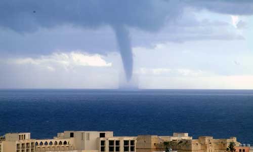
A vigorous low pressure system passed over the Maltese Islands from early Monday 5th January 2009 with thunderstoms and heavy rain showers from time to time. The worst storm was one that passed over the Maltese Islands around mid-morning with torrential rain in some areas (esecially central and harbour areas of Malta), hail about 1.2cm to 1.5cm in Valletta (which however melted quickly unlike last week) and a brief waterspout which lasted about 5 minutes just off Marsascala at 10:35am.
 What is interesting is that the triple point of this low pressure system either passed over or very close to the Maltese Islands at around this time (as can be seen in the weather chart). A radar image of this particular storm is also taken some time after. The highest 24-hour rainfall total for this day was again at Valletta with 87.0mm. There was flooding in the usual low-lying areas of Malta with some cars being carried away by the flood waters. However, no damages or injuries were reported. A warning for both heavy rain and waterspouts was issued 24 hours previously.
PHOTO TAKEN BY CHRIS HOLLAND
